
We had no problems with our flight and arrived around 9:30 pm Icelandic time. (Which was 11:30 pm Swedish time.) It was still COMPLETELY light outside. We went to the taxi line. The first guy had a full-size sedan. Behind him were several vans. I figured the first guy would pass on us-- 4 people with TONS of luggage (4 large suitcases, 3 rolling carry-on bags, 3 backpacks and a laptop bag) but he said he could take us and proceeded to squeeze it all into his trunk. It took a bit of work and he had to bungee cord the trunk closed, but he got us and all our stuff to our hotel-- just about 15 minutes away.
 |
| Exploring Kevlavik at 10 pm. |
 |
| The harbor in Kevlavik |
We had reservations at A. Bernhard Bed and Breakfast in Kevlavik. When we got there I found a door but it just looked like someone's house door so I wasn't sure whether I should go in. It did have Visa and Mastercard stickers on it.... so I stuck my head in and called "hello" and the owner emerged. He was rather surprised at our huge amounts of luggage for a two night stay! The main house just had two guest rooms that shared a bathroom. We rented the studio apartment-- it was in the yard of the main house-- like a detached garage. It had its own bathroom, a big queen bed, a sofa bed, table and chairs, and small kitchenette. It was very clean and nicely decorated and wonderfully quiet. It also had a cute patio set out front, but we never used that. It was so windy all the time. Breakfast was included and they did that by just stocking the refrigerator and cupboards with breakfast food-- like Swedish breakfast-- hard boiled eggs, vegetables, lunch meat, cheese and various bread for sandwiches, Yogurt and Muesli, fruit, juice and even some cereal and milk. We really liked that arrangement because then we could just eat as we woke up-- and we could also have a midnight snack. It was a nice place and the owner's were very nice. We went for a short walk down to the harbor simply because it was still SO light and then we went back to our room and crashed.
Wednesday morning, the owner of the Bed and Breakfast gave us a lift back to the airport to pick up our rental car. We had ordered a large SUV-- simply to be able to haul all our luggage back to the airport and because we thought the kids would enjoy having lots of space and good visibility since we'd be driving all day. We found it funny to have the rental car girl explain that we weren't allowed to ford rivers in it-- other than that, off-road trails were fine. That struck us as funny with rental car. When we said, we weren't really planning on doing any off-roading, she replied, "Why not? It's fun." :-) My husband asked her where the nearest good volcano to see was and she circled a spot on the map called Baula and we were off. We also rented a GPS because when we'd turned ours on in the morning we'd found it didn't have any maps for Iceland. It has North America and Europe but no Iceland. How does that work?
I should mention that we woke up to torrential rain. That was not promising but we were told that they expected it to clear out by afternoon. . The volcano was beyond the distance I'd investigated so we thought we'd head out there first and then gradually work our way back (hopefully with better weather). We did make a few stops that I'd researched on our way out. We stopped at some small lava caves (Mariuhellar Caves in the Heiðmörk Nature Reserve--just outside Hafnarfjörður).
 |
| Mariuhellar Caves |

 |
| Þingvellir (Thingvellir)--Sorry, the rain kept us from getting many pictures here. |


 | ||
| Yes, this is the "main" road. Wasn't marked any different on our | map than the divided highway. |
 |
| Ah, pavement again. |
When the GPS got us to the name the rental car lady gave us, we could see a ravine and creek and some waterfalls, but nothing of the volcano crater that had been described to us. We were a bit disappointed but after looking around a bit decided we'd just have to head back to our other planned sites.
 |
| Pretty, but where is the volcano? |
 |
| This was the farthest north we got-- not quite the Arctic Circle but close! |

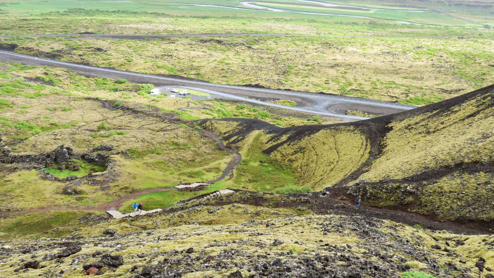
A few minutes down the road, we saw an info spot, pulled over to look at the map and discovered that we had found our volcano, Grabrokargigum. And it was really cool. It had erupted 3000 years ago and there were three craters and these huge hillsides of lava rocks. We followed the trails up through the lava to the tops of the craters. It was a really cool view. By then the rain had stopped but it was REALLY windy up on top with no wind break.
 |
| Climbing up the volcano crater |
 |
| Check out all the lava rock |
 |
| There were several of these-- I haven't been able to find out what they are from. |

 |
| View from the top looking back to the parking area. |
 |
| One of the craters |
 |
| Another crater |
 |
| A nice view of the pathway we walked on along the ridge of the crater |
With all of our stops, it worked out rather perfectly. We'd walk around and look until we were cold and happy to get back into the nice warm car for a while. So we really didn't mind the driving time.
From there, it was a few hours drive back the way we'd come (since there wasn't a better road). We still saw new things because the clouds had cleared so we were able to see mountain ranges we hadn't even known were there. P.lus, everything looked a bit different in the sunlight.

 |
| Waterfalls everywhere! |

 |
| Mountains we didn't know were there. |
 |
| A cool fault area |
Then it was down some new road to Geysir. Geysir is the geyser that all the other geysers are named after. There is a nice geothermal area like some of those in Yellowstone-- hot pools and smalls geysers.


Gullfoss is a huge, beautiful waterfall. It has several levels and as you walk along the trail, you see more and more of it. They let you walk down along the ravine to a overlook right in the mist. We got good and wet (again). I thought it was at least as impressive as Niagara Falls and the atmosphere was a million times better.
 |
| Standing on the lower overlook |
 |
| Rainbow over the falls |
 |
| You can see a person in the mist on the overlook where we were. |
 |
| From this view you can see all the major sections of the falls |
 |
| In this shot you can see people at both the high and low overlooks. |
From the parking lot at Gulllfoss, we could see a huge glacier on the mountains in the distance. So, of course, we decided we had to get closer to the glacier.
 |
| Glacier calling to us from the distance |
All the map showed were little trails going out that way, so we decided to try one. It was pretty rough and pothole filled, and the terrain looked like the surface of Mars. Nothing but tundra type ground and if you looked close, little patches of phlox. Very cool.
 |
| So this is a "trail" |
 |
| Big puddle not a river crossing, right? |
 |
| Surface of Mars |
 |
| Life on Mars |
But when we got to the end of the road-- a dry lake bed-- the glacier was still across a river and behind a mountain. We could see a little white through a crack in the mountain. At first we thought we were glimpsing the glacier, then we realized it was another waterfall.
 |
| Dead end-- no glacier |
We looked at the GPS map and found another trail farther up the main road that it showed running right onto the glacier so off we went to try that one.
 |
| Back down the trail we go |
 |
| Getting into the snow |
 |
| Snowmobiles-- just left sitting in the middle of nowhere until next winter? |
 |
| There was one little lodge out here for snowmobilers-- not open now of course. |
 |
| It doesn't look too far away. |
 |
| Not taking the truck down here |
 |
| Boulder fields |
 |
| And we are on the glacier! |
This was, Langjökull, the second largest glacier in Iceland and just extended out forever-- like a giant frozen sea. And yes, we were the only people out there. Our son, in particular, loved this little adventure. He's the one that has always wanted to go to Alaska. He said it was as cool as Africa which is pretty high praise.
As we hiked back to the truck, the fog descended on us. We'd planned to take a fun picture of our truck sitting all alone on the hill waiting for us but the world turned white and we couldn't see more than a few feet in front of us. We were happy to get back to our vehicle. It was around 10 pm at this point so we figured we'd better head for home. As we came out of the mountain, the fog lightened up and we had a nice drive back to Kevlavik, watching the sun get low in the sky.

 |
| Terrible windshield shot but you can see wisps of geothermal activity all over this valley |
 |
| Getting back to town after midnight. The sun would rise again at 3 am but we weren't awake to see that. |
Thursday morning we took us and our luggage back to the airport, dropped off the now VERY dirty Ford Expedition and continues our journey to the U.S. We would definitely recommend Iceland to any outdoor-minded people. So many cool things to see and so few people! Just dress really, really warm-- even in summer.